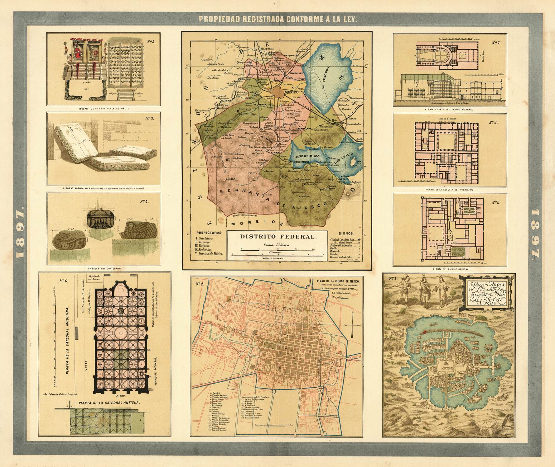
Antonio Garcia y Cubas, one of Mexico’s foremost geographers and cartographers, produced an intricate and detailed map of Mexico City (Distrito Federal) in 1897. This map is a valuable historical artifact that captures the essence of Mexico’s capital at the turn of the century, showcasing its urban layout, key landmarks, and the socio-economic landscape during a period of significant growth and modernization.
The late 19th century was a transformative period for Mexico City. Under the leadership of President Porfirio Díaz, Mexico experienced an era known as the Porfiriato, marked by modernization and extensive urban development. Antonio Garcia y Cubas’ map from 1897 reflects this dynamic period, offering a detailed snapshot of Mexico City’s expansion, infrastructure, and planning. Garcia y Cubas, renowned for his comprehensive and accurate maps, utilized his expertise to create a map that is both a practical tool and a historical document.
The 1897 map meticulously details Mexico City’s urban layout, including its streets, avenues, and major thoroughfares. The grid pattern of the city, a legacy of its colonial past, is clearly evident, with prominent streets such as Paseo de la Reforma, Avenida Juárez, and Calle de San Francisco highlighted. The map also depicts the city’s numerous plazas, parks, and public spaces, including the famous Zócalo, Alameda Central, and Chapultepec Park.
Transportation infrastructure is a notable feature of the map, reflecting the city’s modernization efforts. The inclusion of railway lines, tramways, and major roads underscores the increasing connectivity and mobility within the city. This period saw significant improvements in public transportation, which facilitated the city’s expansion and integration of surrounding areas.
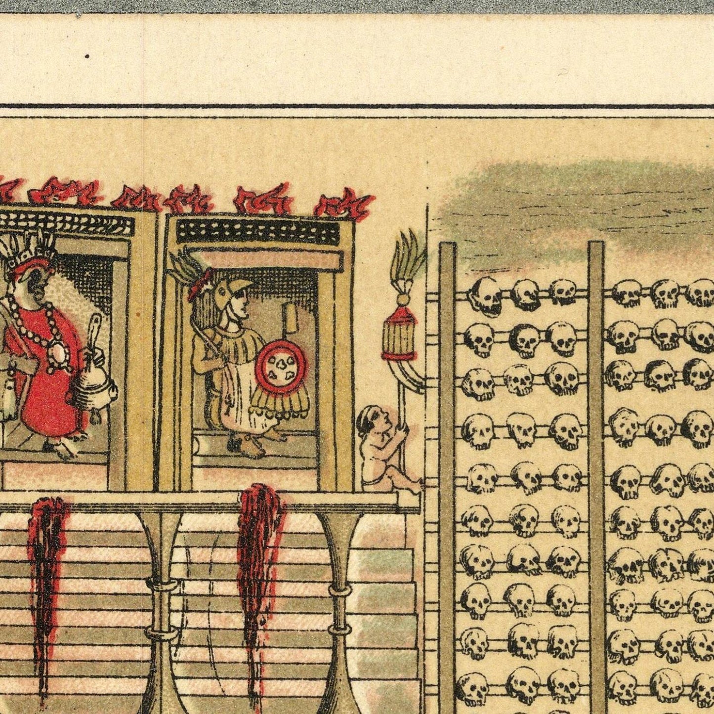
Garcia y Cubas’ map provides detailed representations of key landmarks and architectural highlights that define Mexico City’s historical and cultural landscape. Important buildings such as the Metropolitan Cathedral, the National Palace, and the Chapultepec Castle are prominently marked, showcasing their significance in the city’s history and governance. The map also includes educational institutions, hospitals, and theaters, reflecting the city’s cultural and intellectual vibrancy.
Antonio Garcia y Cubas’ map is not only a practical document but also an example of artistic and technical excellence in cartography. The map features precise lines, detailed annotations, and an aesthetically pleasing design that enhances its readability and visual appeal. The use of color and shading adds depth and clarity, making it both an informative and attractive piece of work.
In summary, Antonio Garcia y Cubas’ 1897 map of Mexico City (Distrito Federal) is a cartographic masterpiece that captures the essence of the capital during a period of significant modernization and growth. Its detailed depiction of the urban layout, infrastructure, and socio-economic landscape provides a valuable window into the city’s history. The map continues to be an indispensable resource for understanding the development and heritage of Mexico City, showcasing the enduring legacy of Garcia y Cubas’ cartographic contributions.